Saturday, October 28, 2006

MacLellan's Castle, Kirkcudbright


MacLellan's Castle
Kirkcudbright
Dumfries and Galloway

MacLellan's castle sits at the junction of the A711 and the B727. Sometimes known as MacLellan's House, the building started life as the Greyfriars Convent from around 1449.


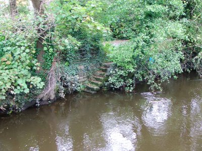
In 1569, Sir Thomas MacLellan obtained the land on which the convent was built, and all but demolished the building, leaving only the chancel of the church standing. This portion of the original building was commandeered as the burial vault of the MacLellan family. The church remains survive today on the opposite side of St Cuthbert's road.

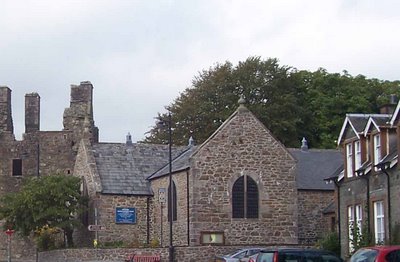
Kirkcudbright's church today. (photo courtesy of Martin Russell)

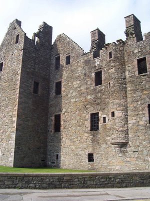
By 1582, the castle was completed, built of stone quarried from the convent, and the ruins of the original royal castle of Kirkudbright (of which no masonry remains today)


The castle, really no more than a fortified manor house, was built for show rather than defensive prowess, and when completed was undoubtedly one of the most spectacular houses in Scotland.

(Photo courtesy of Martin Russell)

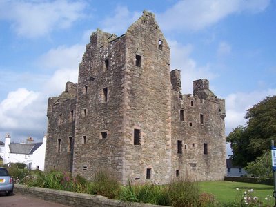
By 1741, the Mclellan family had interests elsewhere, and were probably unable to afford the upkeep of such a splendid castle. They subsequently removed all the furniture, and the roofing materials. The castle slowly fell into ruin, until it was passed into state care in around 1912. It's now looked after by Historic Scotland.


The castle exhibits no signs of attack by anyone....the English or other Scottish clans, and what we see today, is probably the original design. In other words, it hasn't been changed by successive members of the Mclellan family, as is so often the case with castles and large family homes.

(photo courtesy of Martin Russell)

There are a number of gun loops set within the walls of the castle.


All are at ground level, and all are situated near to doorways, therefore providing protection of the weak areas of the castle's defences.


To the West of the castle, the remains of Kirkcudbright's town defences can still be seen, in the form of Castle Dikes\Castle Dykes.....earthworks and ditches, including the remains of a bailey that may suggest that there was an earlier motte and bailey castle.

Above. Floor plans of McLellan's Castle.

Above. Sketch of the castle, dated 1792 

Above. Undated sketch of the castle. 

Above. Postcard (from personal collection) 

Above. Postcard (from personal collection)

The castle is open daily from April to September.

Sunday, October 22, 2006

The Old Bridge, Milnthorpe

The Old Bridge
Milnthorpe
Cumbria
The Old Bridge at Milnthorpe, crosses the river Bela, and lays at the side of the B5282 leading to Sandside and Arnside.

It's likely that it predates the current road bridge by some 50 years. The Old Bridge was built in 1763 by Robert Robinson, a local free mason, and Robert Bindloss, a waller. The bridge cost the grand sum of £90, and replaced a bridge built in 1542, a few yards up the river near a set of steps that lead down to the riverside.

The bridge is now the first access point to Dallam deer park, the route that the road used to follow.

Castle Hill, Beetham

Castle Hill
Beetham
Cumbria

Just off the A6, and a mile to the South of Milnthorpe, the remains of a building platform, sometimes identified as a motte and bailey, can be found in the deer park of Dallam Tower. The remains sit at the highest point overlooking Milnthorpe to the North, Dallam Tower to the West, and Beetham to the South.

The remains consist of a severely damaged platform, with an earth and stone bank around the East, South and West edges, a scarped summit and the slight remains of a ditch to the South. It's thought that the motte was built sometime between 1066 and 1299.

The earthworks were levelled in the 18th century, and much of the top of the site was removed. It was during this work that fragments of stone masonry were found, along with human bones, metal and building foundations.

The site has been variously described as a medieval motte and bailey castle, medieval building platform, medieval ringwork (a precursor to a motte and bailey castle) and a fortress dating from anywhere between the 5th and 11th centuries. Whatever its archaeological worth, the site is well defined and stands sandwiched between the site of the original pele tower that Dallam Tower replaced, and Beetham Hall. Mentioned in The history and antiquities of the counties of Westmorland and Cumberland (1777) by Burn and Nicholson, the site is described "A little Eastward from the hall, is a small hill, on top of which formerly was a castle of a circular form; and the hill is yet called Castle Hill, and the side thereof, Castle Bank."

The footpath that runs through the deer park takes you right past the earthworks, although a deviation of a few hundred yards is required to explore the summit. It's well worth it with the views out towards Arnside and Sandside to the North, Dallam Tower below to the West, and the herds of deer all around the park.

Levens Brow earthworks, Levens

Levens Brow
Levens
Cumbria

Travelling West on the A590, and taking the turning to Levens onto the A6, will take you right past the intriguing earthworks at Levens Brow.

The remains of this site lay on the left hand side of the road, at the peak of a small hill now crowned with a single hawthorne tree.

There has been some confusion in the past as to whether or not the earthworks were of any archeological value, with some commentators saying that they were nothing more than the remains of recent gravel quarry. However, human remains have been found in the area, along with lithic scatter, the remains of worked flints for example, and it's now thought likely that the site's builders merely took advantage of a naturally occuring glacial deposit mound.

The site is a nicely formed scooped enclosure, comprising of an earthen bank which runs nearly the full circumference of the top of the mound and stands to a height of around a foot in places, and the remains of a possible ditch to the East of the earthworks. There's no doubt that the site has been damaged by recent attention, specifically in its use as a deposit for household waste!

A nearby glacial morain was found to contain a human burial, and field walks done in nearby fields, turned up axe heads and other flint tools. It's therefore quite likely that the whole area, extending right down the lands now occupied by Levens Hall, were active well before the medieval hall was built.

It is nearly impossible to gain access to this site, due to the lack of gates on the East side of the road, and the high hedges growing on high field banks. A little scrambling is therefore required to access this area.......but don't get caught!

Romano, British settlement, Hutton Roof

Hutton Roof,
Cumbria
About two miles to the West of Kirkby Lonsdale, and about a quarter of a mile off the A65, lay the remains of a large Romano, British settlement. Easily accessible from the nearby road, the public footpath runs right alongside the remains, affording good views right around the earthworks that survive today.

As you approach the remains from the nearby road, the earthen bank that encircles the settlement can be clearly seen. It consists of a bank that runs nearly the full circumference of the settlement, that is, in some places, around a foot high. At one point, for about ten metres, the bank is topped with limestone boulders, possibly original. In the centre of the remains, more earthen banks can clearly be seen, possibly marking the remains of buildings and further enclosures.

The site is well protected. It sits at the highest point for a few miles around, with flat land to the South. To the East and North, the settlement is protected by natural limestone escarpments, and to the West, the land drops away. It's easy to see why this spot must have been chosen as a place to settle.

All in all a great site to visit, and readily accessible from the nearby road.

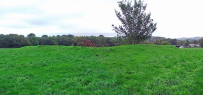
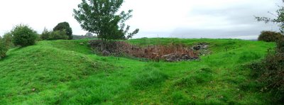
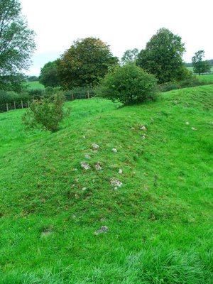
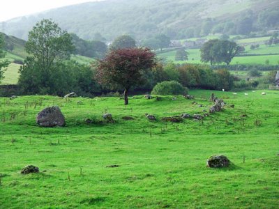
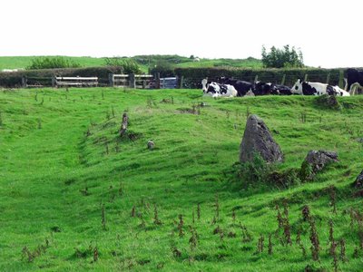
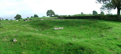
Excavations that took place at this site revealed pottery and the remains of several buildings within the protective earthen banks.

Sunday, October 01, 2006

More of Kendal's buildings

Kendal Work House 
Windermere Road
Kendal

What's left of the Kendal Work house has been converted to townhouses now, in a development called Strickland Court.

Originally built in 1769 on Windermere Road, in those days called House Of Correction Hill, the work house was able to accomodate around 80 people. In 1776, plans were drawn up that would enable it to take in more of Kendal Parish's poor. In 1795, there were around 136 people in the Work House.

Above. Kendal Work House Manager's residence. 

In 1800, the children of the Work House were employed to teas wool, which was then handed to the adults to weave on hand looms, for the production of 'hardens', a form of coarse sacking. This form of work was carried out on the premises for around 50 years. From the 1820's, children at the Work House, were offered out to local businesses as apprentices.

Above. The manager's house and the courtyard.


 In 1809, on the South side of Kendal, another work house was opened up. The residents of this institute were offered to local farmers as workers and farm hands. This work house was situated at Anchorite Place, formaly known as Poor House Lane. In 1861, the Work House contained a wing for the 'elderly and infirm' , a dining hall, stores and workshops. One wing contained the master's accomodation (still in existence today) and offices. The West wing contained able bodied accomodation and a padded room for 'imbeciles'!!

The Work House eventually became Windermere Road Institution. In 1948, it was known as Kendal Green Hospital, and in 1970, after the hospital closed, some of the building were demolished....mainly leaving the U shaped collection of buildings today known as Strickland Court.

Aynam Road Fire Station 

Situated at the East end of Miller Bridge, the buildings are pretty recognisable as an old fire station. There are three doorways where appliances would have been kept, with a large rear yard for their maintenance. As soon as I have more information regarding these buildings, I'll update this post.


Sandes Hospital 


The hospital was built in 1659 by Thomas Sandes, a wealthy local cloth merchant and mayor of Kendal.

Above. Kendal Civic Society's green heritage plaque. 

Above. The entrance leading to the Alms houses. 

Above. Donation box for the widows living at the hospital. 

Above. Date stone showing the date the hospital was built, and the date it was refurbished. 

Above. The chapel.

The intention was to provide eight alms houses for poor women of Kendal. At the West end of the yard, he also built a school, later to become known as the Blue Coat School.


The gatehouse that faces out onto Highgate, was rebuilt by Miles Thompson of the Webster firm of Kendal in 1852. In 1886, the Blue Coat School merged with Kendal Grammar School, and then in 1980, was succeeded by Kirkbie Kendal School, the trustees of which still own the property today. The Blue Coat School has since been converted to flats.


The alms houses are accessed through the gatehouse, and are built on the right hand side of the yard. Just inside the gatehouse, the iron poor collection box still exists with its plead of "Remember the Poore".