Thursday, August 24, 2006

Killington Hall, Killington

Killington Hall
Killington
Cumbria

Killington Hall lays in the small village of Killington sandwiched between Sedbergh and the M6 motorway. The hall is sited opposite the 14th century church of All Saints down a private road. It's attached to a 17th century hall house and is a ruinous state. It's likely that the church is of the same period, and may once have acted as the Manorial chapel to the hall and its residents.

Built in the early 1400's, probably by the Pickering family, the original pele tower was sited over the top of an earlier 14th century moated site, and consisted of a three storey defensive structure.

Above. Floor plan of Killington Hall. 

The crenellations have long since gone, as has most of the top floor, presenting us today with the empty shell of the tower, attached to the 17th century hall or manor house.

The tower, still attached to the house which is inhabited to this day, has no structure within its walls, except for the timber remains of a 19th century larder. The floors have long since collapsed, and the roof is also gone. Some of the fine sand stone windows are still intact, and the moat is little more than a boggy stream surrounding the tower on three sides.

The squat tower seems to be in a good defensive position. There is a shallow ravine with a beck running in it to the South, and another beck to the North, both providing adequate water to make the surrounding ground boggy and difficult to traverse.

Above. Old photo of the hall. Not much has changed.

Killington hall is rare, in that the original hall\tower, is preserved along with the original manorial chapel. Unfortunately, the church was not open on the day I visited the hall...a good excuse to re-visit.

Kilchurn Castle, Glenorchy and Inishail

Kilchurn Castle
Glenorchy and Inishail
Lochawe
Scotland

Sometimes referred to as Kilcairn Castle, the building was erected in around 1450 by Sir Colin Campbell, first Lord of Glenorchy. It started life as a tower house with a strong surrounding wall, but by 1500, a range and hall had been built on the South side of the castle. Further additions were made right through to the 1600's.


Above. Kilchurn Castle from the Eastern shores of Lochawe (from personal collection)

When the castle was originally built, it was on it's own small island, much as Castle Stalker is today. However, as the Loch has changed over the ensuing 600 years, the island is no more and the castle finds itself on the shores of the loch.


Above. Kilchurn Castle from the West.

During the Jacobite rebellions of 1717 and 1745, the castle was garrisoned by government troops. It was more or less abandoned by the Campbells in around 1740, although ownership was maintained by the family. In 1760, the castle's demise was sounded when a severe storm resulted in a lightning struck tower falling into the courtyard. The upturned tower remains there to this day. The castle, as a result of the storm damage was fully abandoned, and the Campbells moved to Taymouth Castle to concentrate on other estates.
Above. Kilchurn Castle (postcard from personal collection)

The castle can be approached from across the loch by boat in the summer months, or on foot around the shores of the loch. Alternatively, as in the photo above, it can be viewed from the A819.

Wednesday, August 23, 2006

Tower of Refuge, Isle of Man

Tower of Refuge
Douglas Bay
Douglas
Isle of Man

The Tower of Refuge sits on a low slung rock called Conister, or St Mary's Rock. At high tide, the rock is invisible, and before the tower was built, posed a serious threat to ships as they made their way into Douglas Harbour from the North East. The tower was built in 1832, and had no military significance. Instead it was placed on the low lying rocks as a way of warning sea borne traffic of the hidden rocks at high tide.


Built at a cost of around £255, the tower was designed by John Welch, and consists of three towers linked together to form a triangular structure, with a single tall square tower behind it. The tower's purpose is to provide a safe haven in the event of a wrecking. It is now in the hands of the RNLI, whos flag flies from the tower.

The Tower of Refuge at low tide. (Photos courtesy of Martin Russell)

Castle Rushen, Castletown, Isle of Man

Castle Rushen
Castletown
Isle of Man

Castle Rushen sits on the banks of Silver Burn, over looking Castletown Bay. The castle is a fine Medieval structure built on the site of a Viking fortified site. The castle has some stone work dating from the 12 century, but most of the surviving structure is dated from the late 13th century, right through to the 16 century.

Interior of the curtain wall. (Photo courtesy of Martin Russell)

The Round tower and the Derby house (not pictured) date from the 16th century.Between 1813 and 1827, the keep was used as a prison.

Part of the keep. (Photo courtesy of Martin Russell)

A large scale restoration project was undertaken in 1910, to restore the castle as mush as possible. The result is one of the finest preserved medieval castles in the British Isles. The base of the keep walls are reputedly 12 feet thick, tapering to 7 feet at the tops. The whole castle is surrounded by a 25 foot high curtain wall, over 7 feet thick in places. Towers have been placed at irregular intervals, to provide good line of site in the event of a siege. The castle is open to the public between the months of April and September.

Saturday, August 19, 2006

YORK: Acomb: ROC Group HQ No 20

York: Acomb: ROC Group HQ No 20
Cold war bunker
Acomb Road
York
Yorkshire

The cold war bunker at York has recently opened its doors thanks to English Heritage and a large chunk of cash (reputedly £240,000) The bunker is situated behind Shelley House on Acomb road in York, and is open for pre-arranged tours. Based on photographs of the interior in 1991, when it was 'stood' down, its appearance, including a large collection of equipment such as computers, telephones and uniforms, has been re-constructed as authentically as possible. Also in situ, are maps and recording equipment that would have been used to monitor radioactive fall out in the event of a nuclear attack on the UK.

Photography was forbidden on the tour, hence the only shot I have is of the exterior of the bunker, but needless to say, it's a tour well worth taking.

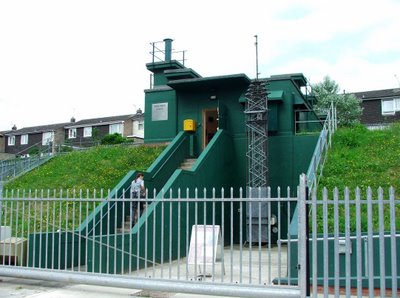
The bunker is a semi-submerged structure, built into a mound of earth a story high, and accessed by a flight of stairs up the outside. The bomb proof door is still in situ, as is the pump up arial at its side. Once inside, there are an further two floors beneath the earth.

Once inside, the bunker is pretty much like a large house (without the windows of course). There's a kitchen and canteen, dormitaries to sleep a staff of 60 in shifts, the plant room containing the deisel generator, a telephone exchange room with impressive faraday cage, the Control room from which the trajectory of radioactive material would have been monitored and all presented pretty much as it would have been when in action!!!

The tour is presented by a member of English heratige, and the young lady that took our tour was very knowledgable and answered all of our questions.

The bunker was opened for operations in 1961, and found itself on high alert during the Cuban missile crisis of 1962.

Well worth a visit.

Clifford's Tower, York

Clifford's Tower
York
Yorkshire

Clifford's tower is perhaps the most visible and most recognisable symbol of York's military history. The tower was built in 1068 by William the conqueror, the first of two motte and bailey structures. The second, The Old Baile, was built a year later. The building of both castles resulted in the destruction of one of the seven shires into which York was divided. Cliffords tower sits on the East banks of the River Ouse. Both castles would have been significant defencive structures for their day....until they were destroyed by English and Danish armies in September 1069....literally dismantled by the invading Danes under Swein of Denmark (nephew of King Cnut) The Danish invasion and sacking of York briefly gave the English a hope of evicting William the Conqueror's occupying army. However, William paid the Danish army to leave and quickly re-established his control over the city. The resulting 'Harrying of the North' saw huge swathes of the countryside obliterated of all signs of life, partly in revenge and partly military strategy. By the end of the year, both castles had been rebuilt.

In 1190, the keep of the motte was severely damaged by fire in the anti-Jewish riots that took place in the city. Once again, the castle was re-built, this time on a higher motte. In both these periods (pre and post fire) the castle was built in wood....a state of play that remained unchanged until the 13th century. During 1902\03, archaeological digs on the motte discovered a layer of charred material, probably relating to the fire of 1190....this material laying some thirteen feet below the summit of the motte, demonstrating the rebuilding that took place after the devastating fire. The castle was surrounded on three sides by the Rivers Foss and Ouse, helping to provide the fortification with enhanced protection.

In 1228 disaster struck again, when the wooden castle was blown down in a gale. No rebuilding work was done for 17 years, until Henry III gave instructions for the castle to be rebuilt in wood and stone. By 1270, the castle was once again complete. Two of Henry III's chief castle builders were employed to make sure that the castle was built to its maximum strength: Henry de Reyns, Henry's master stone mason, and Simon of Northampton, Henry's master carpenter.....both of whom had worked on Windsor Castle. Over the next twenty or so years, over £2500 was spent on improvements. It is thought that the quatrefoil design for the tower was taken from Henry de Reyns tower at the Chateau de'Etamps, some thirty miles South of Paris. Each lobe of the tower possessed two arrow slits, allowing those occupying the castle to keep watch in all directions. Significant repairs were required after flooding in 1315 and 1316, and yet more in 1360 when part of the motte collapsed causing cracks to appear in the tower's walls. Some £200 was spent during this period, on repairs, and some of the repaired cracks are still visible today.

The castle was largely untouched until the 1660's, most likely due to the diminishing threat from North of the border. From the early 1500's, the castle became more of an administrative centre than a military stronghold, and it was allowed to fall into a state of disrepair. In 1596, the city gaoler, Robert Redhead was responsible for removing large amounts of roofing material from the castle, and it wasn't until the city council brought the theft to the attention of the crown, that he was stopped.

The 1600's saw a period of building in the bailey region of the castle, and the keep on the motte transformed into a gaol. The tower was by this time, demoted from a defensive structure in this respect, and the castle promoted to the centre of civil administration for the city. In 1614 the tower was leased out by James I so that he didn't have to pay for the many repairs that the castle required, but at the outbreak of the civil war it was home to a Royalist garrison. In 1643 the upper floors and the roof were strengthened to enable a number of cannons to be stationed there. During the siege of York in 1644, the tower came under fire from Parliamentarian cannon, suffering some minor damage. It was repaired in 1652, and continued to be garrisoned under Charles II. In 1684, a fire spread to the gun powder store in the tower, causing a huge explosion. Much of the wood of the tower was destroyed, and the walls were seriously damaged. Minor repairs were made, and it was garrisoned right up until 1688, when it eventually passed into private hands. As soon as it became a privately owned structure, it lost all military use, and became a 'garden feature' with a spiraling footpath from the foot of the motte to the summit.

The tower, including the castle's building beyond the motte, remained standing through the 1700's, largley unchanged. It wasn't until the 1820's that prison reformers began to demand that the prison conditions at York gaol be improved, and in 1824, a decision was made to enlarge the prison, and provide larger cells, with more security. Land adjoining the castle was purchased for this purpose, and for a short time it looked likely that the tower and the motte upon which it stood was in danger of vanishing for ever. The tower survived though, even though the motte was revetted with a huge wall right around its base. The new prison was built, and the tower was spared....however, other parts of the castle vanished: the gatehouse, most of the curtain wall and most of the buildings within the walls. In 1900 the castle was no longer a public prison, but had been turned over to the military for their use. It remained under their control until about 1929, after which most of the prison buildings were dismantled, except for the debtor's and women's prison which now house the museum. The revetment around the base of the motte has long since gone, and the motte has been restored and strengthened, and the the tower is now open as a tourist attraction.

Thursday, August 10, 2006

Brougham Hall, Brougham

Brougham Hall,
Brougham,
Cumbria

Brougham Hall sits just outside Eamont Bridge near Penrith, on the B6262. The hall is a mis-mash of buildings dating from the 1400's right through to the 1930's.

Above. View of the external walls looking South.

Large parts of the Hall were built during the early part of the 13th century, when a cow house, great hall and a fortified manor were erected by Gilbert de Broham. A licence to crenellate was granted to Ricardus de Brun in 1307, and it is likely that the walls were built at this time.

Above. Interior of the ruined chapel with Christ on the crucifix.

During the 16th century, further buildings were added to the interior of the site, and a pele tower was built during the 17th century. Lady Anne Clifford of Pendragon, Penrith and others fame restored the hall and its buildings around this time.

Above. External walls of the chapel.

The site as a whole became derelict in the late 18th century, and was largely rebuilt in the 1900's. Little of the Medieval remains are visible today, although the hall has undergone a great deal of re-building in the last decade or so.

Above. Looking across the rooftops towards the gatehouse.

The gatehouse has been spectacularly rebuilt, as have some of the internal buildings and the wall surrounding the site.

Above. The North East range of buildings against the courtyard walls.

There is a car park at the front of the hall, and entry is free if you want to have a look around the ruins.

Above. The Southern gatehouse.

Above. The walkway across the B6262 to the church.

Above. The main gatehouse on the North side of the courtyard.

Nearby are the ruins of Brougham castle, the Mayburgh Henge, King Arthur's Round Table, and the historic town of Penrith with its castle.

Follow this link to the official Brougham Hall web site.

Arnside Tower, Arnside

Arnside Tower,
Arnside,
Cumbria

Built in the late 14th century, Arnside tower is unique amongst the pele towers and tower houses of Cumbria and the South Lakes area, in that it is a free standing tower that never had any surrounding buildings attached to it. It's seen its fair share of disaster and damage as well. It was seriously burnt in 1602, and suffered disastrous damage after a storm in 1884. The fire in the early part of the 17th century caused significant damage, although the structure was important enough for repairs to be made.

It was occupied until the 1680's, after which, the roof timbers were removed to Beetham and Knowsley. The storm, in 1884, almost totally destroyed the internal cross wall, causing the South West wall to collapse.

The walls that exist today, are around 1.2metres thick, maybe too slight for the tower to be truly classified as a 'pele tower'. Arnside is one of a number of towers that can be found around the Morecambe bay area.

Other towers in this group include Hazelslack, Wraysholme and Beetham. The tower is situated on a public footpath near Arnside Tower farm sandwiched between Silverdale and Arnside, and is easily accessible for photographing, although the structure is in a very poor state of repair and should not be entered.

Some commentators have suggested that the tower was originally built as a hunting lodge, and does not actually belong to that well known group of fortifications, pele towers.

There are no vaulted rooms\basements present in the remains (an important factor when defining pele towers) the walls are, as mentioned above, thin and slight for a pele tower. Some commentators even go so far as to theorise that the tower could in fact be a complete 17th century rebuild (after the fire of 1602) and there is little to date it to the 1500's at all....such is the 'blandness' of the architectural features we see today. Whatever its history though, pele tower or not, this is a very interesting building set in beautiful surroundings. It desperately needs some consolidation work on those walls in perilous condition, if it is to survive into the future.