Sunday, September 17, 2006

Lime Kilns, South Lakes

Lime Kilns in South Lakeland
Cumbria (and a few in North Yorkshire)

Dotted around the Cumbrian countryside, in fields, at roadsides, on country walks and in the middle of nowhere, you can find lime kilns. Not limited to the Cumbrian landscape, these relics can be found all over the country. So far I've only managed to photograph a few local kilns, but there's more to come. Lime kilns were used from medieval periods right through to the 18th and 19th centuries. They were used for in earlier times for the production of mortar for building purposes, and sometimes, as during the 18th and 19th centuries, for the production of lime for agricultural purposes.

Helsington lime Kiln

This kiln lays in a field about a mile off the A591, sandwiched between Natland and Brigsteer. It is about a hundred yards from the deserted medieval settlement. It is fairly intact, except for the collapsed roof.

Cunswick Scar lime kiln

The lime kiln on the Cunswick Scar lays about two miles into the walk leading to Cunswick Hall. The lime kiln is almost totally intact, and looks to be in excellent condition. It's off the beaten track so has probably escaped any stone robbing.

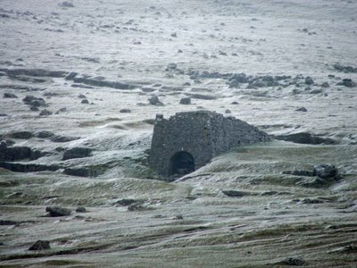
Wild Boar Fell lime kilns

These lime kilns lay half way up the fell side on Wild Boar Fell just off the A683 about 6 miles South of Kirkby Stephen. They're in a remote position on the fell side and again look in pretty good condition.

Longbarn Lime Kiln

This lime kiln lays about 200 yards off the A65 on the South side of the road, at the foot of a steep and narrow hill on the B road heading towards Hutton Roof. The kiln is very overgrown, but in really good condition. I only noticed this by chance as I was making my way to the earthworks outside Hutton Roof.

Lime Kiln at Levens, a quarter of a mile North West of Levens Hall
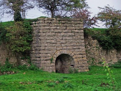
This lime kiln can be seen from the dual carriageway (A590) as you're travelling towards Kendal. The kiln sits in the field on your left, built into a lime stone escarpment. Again, the kiln is in excellent condition. During the summer months, it's pretty much hidden by the roadside hedgerows.
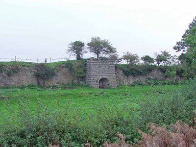
Lime kiln, Storrs Common Ingleton

At last, I've photographed this rather sorry lime kiln just outside Ingleton. The mostly buried remains are about 100 yards west of the B6255 on Storrs common. The entrance to the kiln is full of grass covered rubble, but a quick look inside proved it to be in very good condition.

The kiln was in use in the 1840's, though its date of construction is not known. The area surrounding this kiln, known as Storrs Common, has probably been quarried for centuries, providing good quality lime stone for building and lime production.

This was probably the last kiln to be built on the common, and is the only survivor found to date.

Quarry works, Storrs Common Ingleton

The quarry works in Ingleton are in a poor state. There are a lot of remains at the site, but what's there is pretty ruinous. The kiln is situated on the east banks of the River Doe, on the opposite side of the river to the main part of Mealbank quarry. Its likely that the kiln mostly used lime quarried from the smaller quarry above it, but this would need to be confirmed. The remains also include the infilled ruins of a large kiln built into the hillside to the South of the works.

Infilled lime kiln to the South of the quarry works.

About two miles West of the quarry works and Storrs Common, there is a Hoffman Kiln built by the Craven Lime Company. Two brothers from Austwick, John Clark and Michael Wilson purchased the Meal Bank quarry in 1864, obtaining their license to build a Hoffman kiln four years later in 1868. This was the first Hoffman kiln to be built in the North of England, and at its peak, was producing between 40 and 60 tons of high grade lime a day. My next trip to Ingleton will be to grab some photos of the remains.

Gleaston Lime Kiln, Cumbria.

Just outside the village of Gleaston, and about a mile and ahalf from Gleaston Castle, this lime kiln, in pretty good condition, still stands in the fields overlooking the B road to the village. The farmer has obviously converted the kiln for farm use, but apart from the obvious changes, it's in excellent condition.

Holme Park Fell lime kiln.

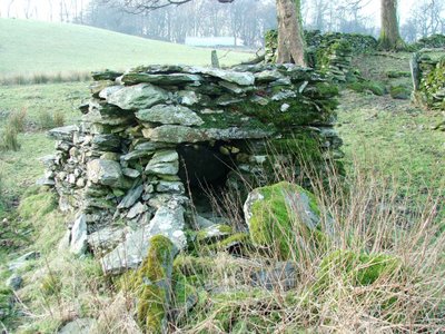
Another fine example of a Cumbrian lime kiln, this time somewhat overgrown, but in good condition. This limekiln can be found on Holm Park Fell, which is about two miles to the South of Fareleton Knot, and a mile and a half East of the village of Holme. I only stumbled on this one really, as it's off the beaten track and as you can see....it's overgrown and well hidden.

Shap lime kilns

Dotted around the fells near Shap abbey, are numerous lime kilns of varying condition. Here are a few that were easily photgraphed.

The first kiln, shown below, is known to date from the mid to late 19th century, and has ramps on the sides, leading to the top of the kiln. In quite good condition.

The next kiln, shown below, was also in good condition, with a shallow trackway leading to the entrance.

The next kiln lay in a shallow 'quarry', perhaps 3 or 4 feet deep, from which lime stone was possibly removed for processing.


There were a number of other kilns that weren't photographed....I'll save them for another day. The area is littered with lime stone outcrops, clearly indicating that the area was ripe for lime stone quarrying.

Arnside Tower Lime Kiln

With Arnside Tower being located along the Limestone Link Walk from Beetham to Kirkby Lonsdale, it's no surprise to find a few lime kilns along the way.

This one is situated right underneath the imposing ruins of Arnside Tower, and probably dates from sometime in the early 18th century.

Partly collapsed and full of rubble, it's a tiny variation on a theme that is common around these parts, with limestone pavements exposed at almost every turn.

Levens Park Lime Kiln.

I only spotted this lime kiln by accident, tiny as the opening is, and damaged and fairly well hidden.

It's only visible from the East banks of the River Kent as it passes through Levens Park. Judgin by the damage on the top, and the silting up of the entrance, I would say that this kiln regularly gets flooded by the Kent.

Ravenstonedale Lime Kiln.

Sad as this may sound, I've only just discovered this lime kiln photo in my library. I know that it's from the Ravenstonedale area, and I know that I took it in September last year...but apart from that, at the moment at least, I don't know where it is.

As soon as I've worked out where it is situated, I'll have a little more information on it.

Saturday, September 16, 2006

Cultivation Terraces, Ingleton

Medieval cultivation terraces
Ingleton
North Yorkshire


In a field at the junction of the B6255 and the Clapham Old Road in Ingleton, a series of 5 medieval cultivation terraces can still be seen in the field to the North of the road.

As can be seen from the above aerial photograph, the terraces are extremely well preserved, and are accompanied in the landscape by another group of terraces above and to the left.These terraces were probably created during the 13th or 14th centuries, and would have been built to make better use of a sloping area of arable land. The terraces would have made it easier for the medieval farmer to make use of the land.
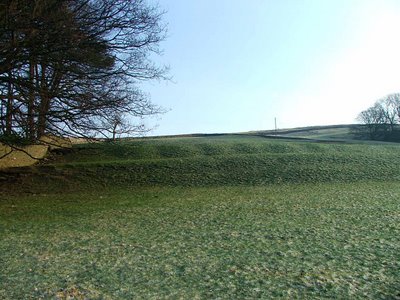
The Ingleborough Park terraces survive to about a metre high, and each terrace is around five to six metres in width, running the whole length of the present day field.

Friday, September 15, 2006

Gleaston Castle, Aldingham

Gleaston Castle
Aldginham
Cumbria

Gleaston Castle is situated about two miles West of Aldingham, with Scales to the North and Gleaston to the South. The castle sits in a field attached to a large farm. It is not accessable due to the ruinous state of the remains, but can be viewed extremely clearly from the road to the East.

Above. View of the South East tower.

In 1297 John de Harrington I, Lord of Aldingham and Muchland began the construction of what is now the South-west Tower and part of the west wall ending with another tower, although the site had been inhabited since the early part of the 13th century.

In 1325, the building of the present day castle was started by either John de Harrington I or his son John de Harrington II. The building work was completed in around 1340. The castle was inhabited by the de Harrington family for 118 years until, in 1457, William de Harrington, last Lord Harrington of Aldingham and Muchland, died with no heir. The castle and estate passed to Lord William Bonvilla and eventually passed by marriage to Thomas Grey, great-grandfather of Lady Jane Grey. It was during this time that the castle gradually fell into rapid decay. Thomas Preston purchased the castle and ‘renovated’ one of the towers in which he lived for a number of years.

Above. Another view of the South East tower.

The Preston family retained ownership of the castle until around 1639 when it seems that a Richard Gaitskell was living in the castle, possibly occupying one of the South towers. He may have occupied the site until the 1690's.

The ruin later passed to the Cavendish family, and was sold by Lord Richard Cavendish of Holker Hall to Thomas Barton Jackson, of Bolton Manor, Urswick, a local farmer, on the 14th February 1920. It was bought by William Simpson Webster Snr in 1926 and is currently owned by his son, William Simpson Webster Jnr and is still part of a working farm.The castle is a very simple lay out, with a large curtain wall running the full circuit of the castle, two corner towers, one at the South West corner and one a the South East corner, a large keep at the North West corner, and a gateway through the East wall. The state of the remains vary considerably. The keep is fairly ruinous and now consists of two ruined walls with no roof. The corner towers have both been incorporated into the farm buildings, and are still fairly solid. The curatin wall on the road side has been demolished and only a dry stone walls survives in its place. The North wall and the South wall are both now gone, and only portions of the West and East wall survive. All in all, it's a spectacular castle, with substantial, if ruined, remains.

Above. View of the South West tower.

Near to this site are the remains of Aldingham motte and bailey castle, and Aldingham Grange, the remains of a moated manor house.

Above. View of the South West tower (left) and the West tower (right)

2007 photos of Gleaston Castle.

Above. View of the Eastern portion of the curtain wall, now built into the field wall\farm boundary.

The wall that seperates the road from the castle courtyard is made up of the lower few feet of the remains of the curtain wall....either in its original make-up, or rebuilt for this purpose. Part of the wall has also been incorporated into the cow barn that is built on the verge of the road.

This photo shows the remains of the North East tower...now in a very ruinous state. The sandstone window still remains in-situ, as is the case on many of the higher windows in the castle ruins.

The South East tower remains are also in a perilous state.

The rear of the South East tower is still intact enough to be able to see passageways, windows and walkways built within the walls.

There still appears to have been no work done on the remains at Gleaston castle by English Heritage, although judging by the state of the ruins, it would not only be a costly exercise, it would be a challenging project for anyone to undertake.

Castle Howe, Kendal

Thursday, September 14, 2006

Trainford Brow, nr Clifton

Trainford Brow Long Cairn,
Nr Clifton,
Cumbria

Less than fifty yards to the West of the A6, where the road way crosses over the M6 motorway, about 1 mile outside of Clifton, lays the Trainford Brow long cairn. At first glance, the mound of earth looks little more than that, a long mound of earth following the path of the minor road to Lowther.

Above. A view of the cairn looking West.

In reality however, it's likely that this is a Neolithic Long Cairn or Bank Barrow. The earthworks are 101 metres long, and point in an East Westerly direction. Its width varies between 13 and 28 metres, and it stands to a height of between 1.5 and 3.8 metres.

Above. A view along the top of the cairn, looking East.

Long Cairns\Bank Barrows are earth work burial sites, usually containing human remains in small pockets of earth, rather than in chambers as is the case in larger barrows. The Trainford Brow long cairn was first noticed in 1933, and visited in 1938, when it was it was described as a likely burial cairn.

Above. A view of the cairn, again, looking West.

There's still some argument that this is nothing more than a spoil heap from the neighbouring road and motorway, and curiously enough, a map of 1863 makes no mention of the cairn!!

Medieval settlement, Selside

Medieval settlement\moated site
Nr Selside
Cumbria

This site is about four miles outside Kendal, about a mile North East of Selside. Parking up on the left hand side of the road, the public footpath disapears through the wall to the right, down towards the river Mint. About 200 yards down the footpath, across the new route of the gas pipeline (watch the barbed wire!!!) and the site is on your right hidden in a copse of trees. It's very boggy to the East of the site, so make sure you've got your wellies with you!!

The moated enclosure can be dated somewhere between 1066 and 1544, quite a large time frame I know, but it may have been inhabited, deserted and the inhabited again.

Charcoal burning pit?

The site consists of an inner bank running around two thirds of a moated island, a single earth bank on the South East side, and a double earth bank on the North West. The island is accessable from the North corner, but apparently traces of a causeway have been found in the Western corner.....although I couldn't find these remains!!!

There are feint earthwork remains on the island (now merely a raised area in a boggy marshy area) To the South East of the moated area, lay the remains of the long house.
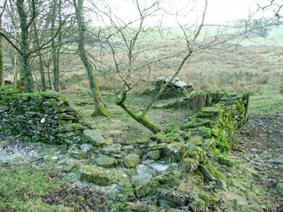
These are by far the most impressive part of this site, and survive in places, to around a meter and a half high. There are definitely two rooms to the long house, with piles of slate rubble where the walls have otherwise collapsed. The remains of a charcoal burning pit have apparently been found in the area, although I was unable to track this feature down.

I'm not sure if the moated site was a defencible structure, or just an enclosure for keeping animals. However, it was quite an impressive site at the end of a pleasant woodland walk.
Berry Holme Round cairn, Helsington

Berry Holme Round Cairn
Helsington
Nr Kendal
Cumbria

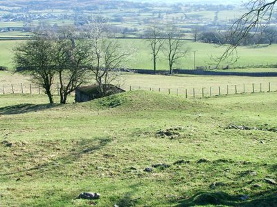
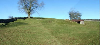
Now this is a strange one, in that I'm not 100% certain that the object that appears in these photographs, is actually the cairn. The day that I went searching for this site, I was only able to find these slight landmarks in the area in which the maps pointed. If you know otherwise, please let me know.

The cairn is directly in front of the small shelter.

Berry Holme round cairn, is a small burial cairn situated to the West of the A6 dual carriageway, on the public footpath that leads to Brigsteer about two miles to the West. The cairn is a simple mound about 1.3 metres high, is oval in shape and has a scooped area to its side containing rubble. The cairn would have contained one or more burials, which may still be there if the site hasn't been robbed.


The cairn is directly behind the shelter on the right.

The cairn has a small hut\shelter built into its side (no antiquity) and this has partially destroyed the site on one side. The cairn is a bronze age structure, so is probably between 4500 and 2500 years old. Difficult to date!!

Dalton Deserted Medieval settlement

Dalton Deserted Medieval Settlement,
Burton In Kendal
Cumbria

About half a mile and to the East of Burton In Kendal, just off the A6070, lay the remains of the medieval settlement of Dalton. The remains are to the left and right of the driveway that leads to Dalton Old Hall (and the remains of the pele tower there) The settlement would have been inhabited anywhere between 1066 and 1540, and would have been an extensive collection of buildings, enclosures, trackways and farm land\field systems.


Above.Field boundary (?)

The remains that can be seen today are quite impressive. There are entire trackways and paths visible, marked out with stone curbs, standing stones and depressions. There are building platforms with some foundation stone work now visible through the soil and grass. Ridge and Furrow remains and lynchets can still be seen at several points on the site (Lynchets are banks of soil at the end of a field that is ploughed over time) (Ridge and Furrow consists of long raised ridges seperated by ditches used to prepare fields for cultivation)


Above. Possible hut circle or enclosure remains.

Enclosures can still be seen in several places. Either as depressions in the earth, or with stones still marking where foundations are buried.


Above.Trackway.

There are also the remains of building platforms, large square or rectangular areas where the earth has been compacted to allow the placing of a large building.

The site is remarkably well preserved, considering that it probably wasn't occupied after 1540, over 460 years ago. The settlement probably stretched far to the East and the West, but the best remains are in the small area to the east of the drive way to Dalton Old Hall and its pele tower remains.

There are numerous deserted medieval settlements in Cumbria, but most either display no evidence, or slight crop marks, only occasionaly visible. Docker a few miles outside of Kendal was reputedly quite a large settlement. The site is next to the railway, and it's likely that any visible remains were destroyed when the lines were laid and the road bridge built. The only other deserted settlement that I've been able to photograph, was Helsington, and even then, the remains were slight crop marks of a long rectangular building, possibly a long house, with two rooms, and some more slight indentations in the field surface.


Above. Helsington Deserted Medieval settlement.

The photo above possibly shows the earthwork remains of the long house at Helsington, or it could simply be the remains of some sort of enclosure. The field in which these remains are sited, is full of slight impressions in the soil, possibly more buildings and trackways. This settlement also dates from around 1066 to 1540, although these dates are only a broad time frame between which the settlement may or may not have been inhabited. There are apparently further earthworks, perhaps relating to the same settlement, 200 metres to the South below the farm buildings.

There are further sites at Mint in Kendal, on the banks of the river near Morrisons. Scalthwaiterrigg on the other side of the road and in a field over the other side of the road from Skelsmergh church. As with Docker, there are no visible remains.