Sunday, October 01, 2006

More of Kendal's buildings

Kendal Work House 
Windermere Road
Kendal

What's left of the Kendal Work house has been converted to townhouses now, in a development called Strickland Court.

Originally built in 1769 on Windermere Road, in those days called House Of Correction Hill, the work house was able to accomodate around 80 people. In 1776, plans were drawn up that would enable it to take in more of Kendal Parish's poor. In 1795, there were around 136 people in the Work House.

Above. Kendal Work House Manager's residence. 

In 1800, the children of the Work House were employed to teas wool, which was then handed to the adults to weave on hand looms, for the production of 'hardens', a form of coarse sacking. This form of work was carried out on the premises for around 50 years. From the 1820's, children at the Work House, were offered out to local businesses as apprentices.

Above. The manager's house and the courtyard.


 In 1809, on the South side of Kendal, another work house was opened up. The residents of this institute were offered to local farmers as workers and farm hands. This work house was situated at Anchorite Place, formaly known as Poor House Lane. In 1861, the Work House contained a wing for the 'elderly and infirm' , a dining hall, stores and workshops. One wing contained the master's accomodation (still in existence today) and offices. The West wing contained able bodied accomodation and a padded room for 'imbeciles'!!

The Work House eventually became Windermere Road Institution. In 1948, it was known as Kendal Green Hospital, and in 1970, after the hospital closed, some of the building were demolished....mainly leaving the U shaped collection of buildings today known as Strickland Court.

Aynam Road Fire Station 

Situated at the East end of Miller Bridge, the buildings are pretty recognisable as an old fire station. There are three doorways where appliances would have been kept, with a large rear yard for their maintenance. As soon as I have more information regarding these buildings, I'll update this post.


Sandes Hospital 


The hospital was built in 1659 by Thomas Sandes, a wealthy local cloth merchant and mayor of Kendal.

Above. Kendal Civic Society's green heritage plaque. 

Above. The entrance leading to the Alms houses. 

Above. Donation box for the widows living at the hospital. 

Above. Date stone showing the date the hospital was built, and the date it was refurbished. 

Above. The chapel.

The intention was to provide eight alms houses for poor women of Kendal. At the West end of the yard, he also built a school, later to become known as the Blue Coat School.


The gatehouse that faces out onto Highgate, was rebuilt by Miles Thompson of the Webster firm of Kendal in 1852. In 1886, the Blue Coat School merged with Kendal Grammar School, and then in 1980, was succeeded by Kirkbie Kendal School, the trustees of which still own the property today. The Blue Coat School has since been converted to flats.


The alms houses are accessed through the gatehouse, and are built on the right hand side of the yard. Just inside the gatehouse, the iron poor collection box still exists with its plead of "Remember the Poore".

Saturday, September 30, 2006

Some of Kendal's interesting buildings.

Historical buildings of Kendal, Cumbria.


Kendal is littered with interesting, quirky and architecturally valuable buildings. From the oldest inhabited building in the town, the Castle Dairy, to the shops on Highgate, Strickland Gate and Kirkland, Kendal has many gems.....some hidden, some plain to see. Here are some photos of some of these buildings, along with a little information.

7 Stramongate
Kendal

Situated at the West end of Stramongate, the house is reputed to have been built in 1546, although the date stone now mounted above the central dormer window is now disputed. Certainly built sometime in the 16th century, it was originally erected as a town house for the Bellingham family, a local well known land owning dynasty.


Above. The yard of number 7, with water pump and stable building at the rear. 


Above. 7 Stramongate was Henry Robert's Book shop.

A local story tells us that part of the house was later occupied by Agnes Harker, Captain Cook's sister, though much research has yet to prove that Captain Cook had a sister called Agnes. Interestingly though, Henry Roberts was a sailor who served with Captain Cook on HMS Discovery. The house is probably the oldest building in Kendal, still used as shop premises. In 1985, the property was restored to its current condition.

Highgate Hotel 
Kendal

The house was built in 1769 and is now used as a hotel. Above the door way onto the street, the following inscription has been discovered: TO THE DWELLERS IN THIS PLACE GOD GRANTE PEACE.


The Inghamite Chapel 
Gillinggate
Kendal

The building we see today, Pear Tree Barn, was built in 1845, but there was a chapel on this site before then.

Above. Plaque showing the date the chapel was rebuilt and converted. 


The Inghamites were a Calvanistic sect started by Benjamin Ingham after he broke away from the Church of England. Locally, the Inghamites were not much liked, and they were not allowed burial anywhere in the town.


The Inghamites managed to purchase a small pocket of land at the top of Beast Banks, about a hundred yards from the chapel, and they used this as their burial ground until it was closed in 1855.

The chapel has been converted to flats now.


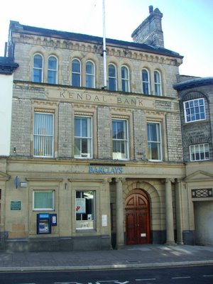
Kendal Bank 
Strickland Gate
Kendal


The Kendal Bank of Maude, Wilson and Crewdson opened on the 1st of January 1788, on the same day as Wakefield's Bank in Stricklandgate. When the two banks joined forces in 1840, they eventually moved to the purpose built Kendal Bank building in 1873. The firm merged with the Bank of Liverpool , which in turn became Martin's Bank in 1928, eventually becoming Barclays Bank in 1969.


Kendal Bank was licenced to print its own money at one point. In 1797, when the Bank of England was unable to pay in gold coinage, at the height of the war with France, the bank issued its own banknotes, called Promissory notes. Many high ranking local businessmen and politicians put their hands to a document in February of 1826, stating that they had every faith and trust in the Kendal Banks, and that they would gurantee money lodged with the banks.

Kendal Moot Hall
 Market Place
Kendal

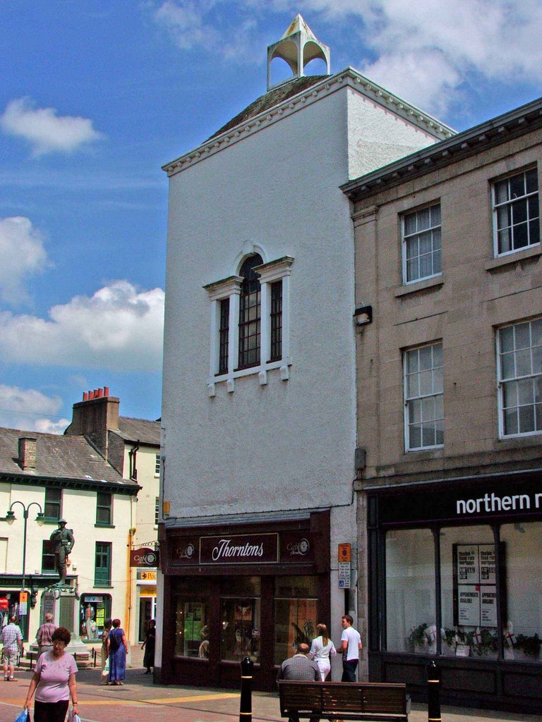
Originally built in 1591, the Moot hall was erected as a town hall, administrative centre of the town, court house and gathering place when the castle was no longer used or usable. It was one of Kendal's timber and stone constructions. It contained offices and the 'Court Loft' where offenders were often kept before they were tried in the courts below. In 1712, on the 11th of October, the Moot hall was the scene of debate, when the magistrates of Kendal summoned surveyors of the town's roads to appear before them. The session was called to discuss why the surveyors had not made essential repairs on the Barony's roads. In 1729, the hall was almost entirely rebuilt, with new windows, a courtroom and an upper storey with a cupola and clock.


The Moot hall was used for court proceedings as well. For example, for the taking of oaths in support of the current monarch: "Summons from Daniel Wilson, John Archer and Anthony Askew to Thomas Shipherd, George Hilton, John Hale, John Burrow and William Clawson, all of Beetham, to appear at the Moot Hall in Kirkeby Kendall, to take the oaths prescribed for the further security of his Majesty's person and Government and the succession of the Crown in the heirs of the late Princess Sophia, being protestants, and for extinguishing the hopes of the pretended Prince of Wales and his open and secret abbettors. Dated 15 December, 1715. Similar summonses to Mrs. Askew, widow in the island in Applethwaite, Miles Atkinson and Benjamin Harrison both of Applethwaite, James Longmire de Linefitt, James Longmire de Orrest, John Longmire de Calgarth and George Elleray de Houe of Applethwaite, Robert Stephenson of Newhouse and George Dennison of Mirehead, both in Grayrigg, Samuel Newby of Tenterden in Docker and Thomas Dawson of Crosthwaite. Dated 15 December, 1715.


And also, in relation to Window taxes: The High Constable in her majesty's name is to issue warrants to the Petty Constables to warn the collectors of the duties on houses and windows to make a strict survey of all houses (except cottages) and take an exact account of the number of windows or lights in each house, from one to thirty, and to charge the inhabitants or occupiers of the same without concealment, love, favour, dread or malice upon pain of forfeiture of any sum not exceeding £5. With three columns:— the first to contain the just number of windows or lights from one to thirty; the second to contain the Old Duty, i.e., for every house having under ten windows, 2 shillings, for every house having ten and under twenty, 6 shillings, and for every house having twenty windows or lights 10 shillings; and the third column to contain the additional duty according to a late act of Parliament, i.e., for every house having twenty and under thirty windows the sum of 10 shillings, and for every house having thirty windows and upwards the sum of 20 shillings, over and above the old Duty. The same to be returned to her majesty's Justices of the Peace as shall be assembled upon Saturday the 4th day of April next at the Moot Hall in Kendall. John Meredith, surveyor of the said duties, will give his attendance to accuse such collectors as shall omit any part of their duty in the premises to the end that the penalty of £20 may be levied of every offender according to law. Given under our hands and seals the 21 day of February, 1712 (extracts taken from British History on line)


The Moot Hall was used as the Town Hall and courtrooms until 1859, when Kendal Corporation purchased the White Hall Assembly rooms at the top of Lowther street and moved their administrative offices there. The ground floor of the Moot Hall was converted to shops with some storage and living quarters onthe first floor. A small police station was also situated here. The top floor of the building was used as the Council Chamber until 1836. Under the market place, the 'Black Hole', a primitive lock up, was situated.....used until this time (1836) when a replacement was built in the new police offices in Old Police Office Yard on Finkle Street. The clock, seen on many old black and white photos of the building, hung from the cupola from 1840 until 1861, when it was donated to the church of St Thomas at the foot of Windermere Road, where it remains to this day.

The original building burned down in 1969 (?) and the replacement was designed to look as close to the original as possible. The original Venetian windows of 1729 are still in situ, shown below.


Photos that I've seen of the main street seem to suggest that the current building is a pretty good representation of the original!! Many of us will remember it housing Thorntons, now a jewellers,  it's a hidden gem in that it's history isn't known by many people.

Sunday, September 17, 2006

Lime Kilns, South Lakes

Lime Kilns in South Lakeland
Cumbria (and a few in North Yorkshire)

Dotted around the Cumbrian countryside, in fields, at roadsides, on country walks and in the middle of nowhere, you can find lime kilns. Not limited to the Cumbrian landscape, these relics can be found all over the country. So far I've only managed to photograph a few local kilns, but there's more to come. Lime kilns were used from medieval periods right through to the 18th and 19th centuries. They were used for in earlier times for the production of mortar for building purposes, and sometimes, as during the 18th and 19th centuries, for the production of lime for agricultural purposes.

Helsington lime Kiln

This kiln lays in a field about a mile off the A591, sandwiched between Natland and Brigsteer. It is about a hundred yards from the deserted medieval settlement. It is fairly intact, except for the collapsed roof.

Cunswick Scar lime kiln

The lime kiln on the Cunswick Scar lays about two miles into the walk leading to Cunswick Hall. The lime kiln is almost totally intact, and looks to be in excellent condition. It's off the beaten track so has probably escaped any stone robbing.

Wild Boar Fell lime kilns

These lime kilns lay half way up the fell side on Wild Boar Fell just off the A683 about 6 miles South of Kirkby Stephen. They're in a remote position on the fell side and again look in pretty good condition.
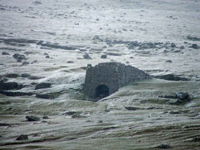
Longbarn Lime Kiln

This lime kiln lays about 200 yards off the A65 on the South side of the road, at the foot of a steep and narrow hill on the B road heading towards Hutton Roof. The kiln is very overgrown, but in really good condition. I only noticed this by chance as I was making my way to the earthworks outside Hutton Roof.

Lime Kiln at Levens, a quarter of a mile North West of Levens Hall
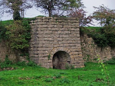
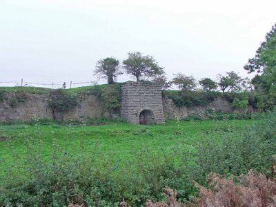
This lime kiln can be seen from the dual carriageway (A590) as you're travelling towards Kendal. The kiln sits in the field on your left, built into a lime stone escarpment. Again, the kiln is in excellent condition. During the summer months, it's pretty much hidden by the roadside hedgerows.
Lime kiln, Storrs Common Ingleton

At last, I've photographed this rather sorry lime kiln just outside Ingleton. The mostly buried remains are about 100 yards west of the B6255 on Storrs common. The entrance to the kiln is full of grass covered rubble, but a quick look inside proved it to be in very good condition.

The kiln was in use in the 1840's, though its date of construction is not known. The area surrounding this kiln, known as Storrs Common, has probably been quarried for centuries, providing good quality lime stone for building and lime production.

This was probably the last kiln to be built on the common, and is the only survivor found to date.

Quarry works, Storrs Common Ingleton

The quarry works in Ingleton are in a poor state. There are a lot of remains at the site, but what's there is pretty ruinous. The kiln is situated on the east banks of the River Doe, on the opposite side of the river to the main part of Mealbank quarry. Its likely that the kiln mostly used lime quarried from the smaller quarry above it, but this would need to be confirmed. The remains also include the infilled ruins of a large kiln built into the hillside to the South of the works.

Infilled lime kiln to the South of the quarry works.

About two miles West of the quarry works and Storrs Common, there is a Hoffman Kiln built by the Craven Lime Company. Two brothers from Austwick, John Clark and Michael Wilson purchased the Meal Bank quarry in 1864, obtaining their license to build a Hoffman kiln four years later in 1868. This was the first Hoffman kiln to be built in the North of England, and at its peak, was producing between 40 and 60 tons of high grade lime a day. My next trip to Ingleton will be to grab some photos of the remains.

Gleaston Lime Kiln, Cumbria.

Just outside the village of Gleaston, and about a mile and ahalf from Gleaston Castle, this lime kiln, in pretty good condition, still stands in the fields overlooking the B road to the village. The farmer has obviously converted the kiln for farm use, but apart from the obvious changes, it's in excellent condition.

Holme Park Fell lime kiln.

Another fine example of a Cumbrian lime kiln, this time somewhat overgrown, but in good condition. This limekiln can be found on Holm Park Fell, which is about two miles to the South of Fareleton Knot, and a mile and a half East of the village of Holme. I only stumbled on this one really, as it's off the beaten track and as you can see....it's overgrown and well hidden.

Shap lime kilns

Dotted around the fells near Shap abbey, are numerous lime kilns of varying condition. Here are a few that were easily photgraphed.

The first kiln, shown below, is known to date from the mid to late 19th century, and has ramps on the sides, leading to the top of the kiln. In quite good condition.

The next kiln, shown below, was also in good condition, with a shallow trackway leading to the entrance.

The next kiln lay in a shallow 'quarry', perhaps 3 or 4 feet deep, from which lime stone was possibly removed for processing.


There were a number of other kilns that weren't photographed....I'll save them for another day. The area is littered with lime stone outcrops, clearly indicating that the area was ripe for lime stone quarrying.

Arnside Tower Lime Kiln

With Arnside Tower being located along the Limestone Link Walk from Beetham to Kirkby Lonsdale, it's no surprise to find a few lime kilns along the way.

This one is situated right underneath the imposing ruins of Arnside Tower, and probably dates from sometime in the early 18th century.

Partly collapsed and full of rubble, it's a tiny variation on a theme that is common around these parts, with limestone pavements exposed at almost every turn.

Levens Park Lime Kiln.

I only spotted this lime kiln by accident, tiny as the opening is, and damaged and fairly well hidden.

It's only visible from the East banks of the River Kent as it passes through Levens Park. Judgin by the damage on the top, and the silting up of the entrance, I would say that this kiln regularly gets flooded by the Kent.

Ravenstonedale Lime Kiln.

Sad as this may sound, I've only just discovered this lime kiln photo in my library. I know that it's from the Ravenstonedale area, and I know that I took it in September last year...but apart from that, at the moment at least, I don't know where it is.

As soon as I've worked out where it is situated, I'll have a little more information on it.

Saturday, September 16, 2006

Cultivation Terraces, Ingleton

Medieval cultivation terraces
Ingleton
North Yorkshire


In a field at the junction of the B6255 and the Clapham Old Road in Ingleton, a series of 5 medieval cultivation terraces can still be seen in the field to the North of the road.

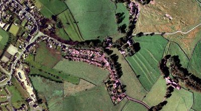
As can be seen from the above aerial photograph, the terraces are extremely well preserved, and are accompanied in the landscape by another group of terraces above and to the left.These terraces were probably created during the 13th or 14th centuries, and would have been built to make better use of a sloping area of arable land. The terraces would have made it easier for the medieval farmer to make use of the land.
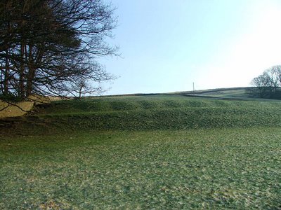
The Ingleborough Park terraces survive to about a metre high, and each terrace is around five to six metres in width, running the whole length of the present day field.