Monday, January 23, 2006

Selside Hall nr Kendal

Selside Hall,

Selside nr Kendal,

South Lakeland,

Cumbria.


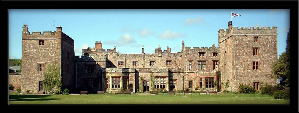
Selside Hall is situated about three miles outside of Kendal, between Watchgate and Garnett Bridge. The pele tower was built in 1540, on the site of an earlier house built in the late 1300’s. The earlier house is no longer extant, but the pele tower, and the 17th century additions are still visible.

The hall is described as a twin tower house, one of 15th century origins, the other of 16th century. Due to the relatively thin walls, the house has easily been transformed from a defensive pele tower, to a house…..and it is for this reason that it is fairly difficult to see at first glimpse the history behind the property.


It is reputed that a room on the first floor of the hall, was at some time used as both an Anglican and a Catholic chapel, until the church, dedicated to St Thomas, was built. There are also mentions of priest holes hidden throughout the house. It is thought that the pele tower belonged to the Thornburgh family of Hampsfield in Cartmel, a staunchly Catholic family. The kitchen is now thought to occupy the room once dedicated to the chapel.


The hall can best be seen from the small car park opposite the church, as the road does not run directly past the hall.

Church of St. Catherine Crook

Church of St. Catherine,
Crook\Nether Stavely,
South Lakeland,
Cumbria

The Church of St. Catherine is a grade II listed building. It sits on the hillside just off the B5284 sandwiched between Crook Hall the road.
All that remains of the church is the slate grey tower, sitting in a walled enclosure atop the hill side with good views of the Cumbria fells all around it.

The church was built in around 1620, but due to its poor condition, was dismantled in 1887.

The tower was left standing as a monument, and has been reconstructed and strengthened to aid its survival.

The tower is reached by walking up the gentle hill side from the road. The walk is about three quarters of a mile, and is best done in fine weather as there is only a marked path for about half of the distance.

Church of St. Leonard Chapel le Dale

St. Leonard’s church,
Chapel–le-Dale,
Nr Ingleton
North Yorkshire.

St. Leonard’s church sits in a small woodland area in the hamlet of Chapel-le-Dale, about two miles outside of Ingleton, just off the B6255. It is a grade II listed building, built in the late 17th century with some 18th century additions. According to English Heritage, it was vastly restored in 1869.

The church is built using local limestone, giving it its ‘local’ grey colour. There is a white marble memorial on the West wall of the Nave which reads:

TO THE MEMORY OF THOSE WHO THROUGH ACCIDENTS LOST THEIR LIVES, IN CONSTRUCTING THE RAILWAY WORKS, BETWEEN SETTLE, AND DENT HEAD. THIS TABLET WAS ERECTED AT THE JOINT EXPENSE, OF THEIR FELLOW WORKMEN AND THE MIDLAND RAILWAY COMPANY 1869 TO 1876

This is dedicated to the workers who perished during the building of the Settle to Carlisle railway, and also those who built the viaduct at Ribblehead.

I’d recommend a trip to this isolated church….but try and make the journey on a good sunny day….it tends to get a bit grey and wet up there!!

Thursday, January 19, 2006

Photos of favourite castles

Piel Castle

Pendragon Castle
Muncaster Castle
Lammerside Castle
Castle Howe Kendal
Brough Castle

Burton in Lonsdale Motte and Bailey

Castle Hill,
Burton in Lonsdale,
Lancashire.

Turning right after Wrayton, travel for around four miles on the A687 towards Burton in Lonsdale in North Yorkshire. You can’t fail to notice the motte and bailey remains on the right hand side of the road as you drive through this large Yorkshire village.
It’s unusual double peaked summit is referred to as a breastwork structure….for obvious reasons. The castle was built on the site of a ring work enclosure, the motte and the baileys (as there are two) being placed within the original defensive site.

The ring work site was constructed in the late 12th century, and then modified into the structure we see today in the early part of the 13th century. The huge motte, stands around ten metres tall, with the ‘breastwork’ structure adding a further three metres to its height. This castle site has two baileys attached to it.

The largest, which sits to the west of the motte, measures some fifty eight metres by fifty metres, and is square in shape. The second, is around 21 metres at its widest point and is a semi lunar shape, and sits to the south of the motte.

The baileys are defined by both feint and well defined earthworks, ditches and mounds. According to local records, the castle fell out of use sometime between 1322 and 1369, when it stopped being mentioned in local taxation records.

The castle and its earthworks were well excavated and investigated in 1904, and it was found that both the motte and the baileys were at some point paved. More information about this motte and bailey castle can be found later on in this blog.

Hornby Castle Stede

Hornby Castle Stede,
nr Hornby,
Lancashire.

Travelling South on the A683, head back towards Lancaster. Just as you enter Hornby, there is a turning to your right, which takes you down towards the river, heading out towards Gressingham. You can safely park in the lay by once you’ve crossed the bridge. Once you’re parked up, head back across the bridge again, and turn left through the stile in the wall. The footpath takes you up a grass embankment, and straight into the bailey of the castle. This is the largest and most intact motte and bailey in Lancashire. The site is widely regarded as the best preserved example of a motte and bailey castle in Lancashire, and it’s easy to see why. This motte and bailey, built later than Melling, is only around two miles down river from Melling motte and bailey, and represents another Norman castle protecting the line of the River Lune.

As you enter the bailey, which lays to the west side of the motte, you cross a recently added earthen causeway. The bailey is huge, estimated at around two and a quarter acres. This portion of the site is apparently built on the site of an iron age hill fort, and its position over looking a bend in the river, must have offered excellent defensive qualities. To the north and the west of the bailey, are well defined ditches and earthworks, marking the site out incredibly well. The motte, which stands some 15 metres tall, is surrounded by a ditch to all sides, except where it slopes off towards the river below it. The castle was built in the early days of the 12th century, but was abandoned some time later, possibly in the late 13th century, when the nearby castle in Hornby was built as a direct replacement by the Longuevillers family. The earthwork remains were put to use during the second world war, when a pill box was situated on the embankment over looking the road bridge.

The motte is very overgrown, with some well established trees growing from its sides. A great deal of work appears to have been done to the motte to stabilise it. It is pitted with rabbit holes, and therefore fenced off….however the foot path runs all the way round it affording excellent views.

The site is easily accessible at all times and deserves a visit to see what a large motte and bailey castle would have looked like.

Melling Motte and Bailey

Melling Motte and Bailey,
Castle Mount,
Melling,
Lancashire.

Travelling through Melling, a small village in Lancashire, the church of St Wilfrid’s lays on your left hand side. The church was built in the 13th century, and vastly rebuilt and redesigned right up until the late 19th century. Local legend has it, that it has suffered serious damage at the hands of invading Scottish armies.

If you park up, and walk into the church yard, you notice that the grave yard begins to slope upwards towards the boundary wall. This slight raise in the earth towards the back of the church yard may well be all that is left of the castle’s bailey. If you look over the wall, into the Vicarage gardens, the motte sits in the middle of the garden.

It is about 6 metres tall, and extremely overgrown. There are a couple of well established trees sprouting from the body of the motte. Unfortunately, the earthwork remains have been severley damaged by landscape gardening around the base, but on the whole, it’s in good condition.

As with Arkholme and Whittington, Melling motte is situated right next to the church. It is suggested that in all three instances, the churches were built on the baileys, and may at some stage, have been manorial chapels\churches built for the express use of the owners and occupiers of the respective castles. This would adequately explain the lack of any discernable bailey at each site. The motte measures around 38 metres in diameter, and is around 6 metres tall, although the mound is higher when measured from the lowest point in the church yard.

It is interesting to note, that the castle is no longer anywhere near to the river Lune. There is evidence to suggest that the river’s course has altered greatly over the last 700 years, and that when the castle was being used in the 12th or 13th centuries, it was nearer to the river side. The river Lune must now be at least a quarter of a mile to the West.

Arkholme Motte and Bailey

Arkholme Motte and Bailey,
Chapel Hill,
Arkholme,
Lancashire.

Head onto the B6254 towards the village of Arkholme. The 12th century castle at Arkholme sits, like Whittington, within the grounds of the 15th century church of St John the Baptist. It also sits right next to the river, which probably acted as a defensive barrier back in its heyday.

The motte is very well defined and in excellent condition. It stands around 6 metres tall and about 30 metres around its base. The bailey is no longer in evidence, although the footpath that runs the other side of the church yard wall, could well be running in the remains of the defensive ditch .

The castle has been excavated, and that there appears to have been two periods of building. It appears that the original castle was some 2 and half metres smaller than the mound that survives today. This earlier phase of building, could well have been a Saxon moot hill (as at Whittington) with the larger Norman motte being built over the top, possibly to indicate to the local population that the Norman lords were here to stay.

As at Whittington and Halton, Earl Tostig held the manor here at Arkholme. And, as at Whittington and Halton, after his death in 1066, the manor probably passed to Ivo de Taillbois. It's frustrating that there appears to be little information on these sites, when they were active, when they were abandoned, and what they were abandoned for.

Whittington Motte and Bailey

Whittington Motte and Bailey,
Whittington,
Lancashire.

Leave Kirkby Lonsdale, and set off down the B6254. About 2 miles down the road, turn off the main road and towards the church of St Michael the Archangel. The mostly 15th century church is built over the top of the castle remains, and the motte is only just visible as a slight mound upon which a grave yard has been laid out.

The bailey and it’s ditches and earthwork defences are no longer visible due to both the church and the grave yard being built on and around them. The low motte is around 50 metres in diameter, and around 12 metres high at its tallest point (topped by a sundial!)

The whole site stands about 11 metres above meadows to the south of the site, perhaps enhancing the defensive aspects of the castle. It is believed that a church has stood on this site since the 1200’s, although the current building dates from the end of the 15th century.

The fact that the church is built so close, in fact over the top of the motte, could indicate that the original church, whatever form it may have taken, would have been within the bailey of the castle. The location of a church so close to the earthwork remains is something that most of the Lune valley motte and bailey castles have in common. This can be seen at Burton in Lonsdale, Melling, Arkholme, Kirkby Lonsdale and Halton.

As at Halton, Earl Tostig is associated with the pre-Norman manor here, and on some early maps, the motte and bailey castle site is marked as a 'moot hill' possibly a place where the Saxon earl would have held court over local affairs. The fact that the Normans built a motte and bailey castle over the site may have been to assert their ownership over the area, and hence to eradicate any reference to the defeated Saxons.

Kirkby Lonsdale Motte and Bailey

Kirkby Lonsdale Motte
Cockpit Hill
Kirkby Lonsdale
Cumbria

Cockpit Hill (as it is known locally) represents the remains of a small motte and bailey castle, one of a large number in the area built on the banks of, or very near to, the River Lune.

The castle remains can be found at the back of St Mary's church in Kirkby Lonsdale, on the Ruskin's View walk.

There is a high wall to your left as you walk with the river Lune below you on your right. Just beyond this wall, in the garden of the old vicarage, the overgrown motte can be seen.

There are two good vantage points. The first is from the graveyard at the back of the church. From here, looking over the wall, the full length of the remains can be seen. It is a long low motte, severely damaged and lacking all signs of the bailey.

The other good view can be seen from the cemetery that adjoins the vicarage gardens. The remains can easily be seen over the hedge here. Close up, it's easy to see the height that the motte retains, some 7 metres high at its highest point.

The eastern side of the motte is damaged, buried beneath the footpath, and by the erosion of the cliff face above the river. It's not clear where the bailey would have been, so many areas of the motte have now been built over or otherwise dug up and used as burial areas. One thing is clear. The North East corner of the current church, which only lies about 50 yards from the castle, was built on the site of a much earlier chapel. There is therefore the possibility that this chapel may have been in the bailey of the castle, and that the building of St Marys, and the demolition of the chapel, may have obliterated the original bailey.

This photo shows the site of the original chapel (represented by the colour area)

The remains are often attributed to Ivo de Tailbois, who also held the manor of Kendal, some 12 miles away. This motte and bailey, along with those at Whittington, Arkholme, Melling, Halton, Hornby and Kendal, represent the biggest concentration of motte and bailey castles outside of Wales.

Pendragon and Lammerside

Pendragon Castle and Lammerside Castle\Tower,
Mallerstang nr Kirkby Stephen,
Cumbria
Here's a brief introduction to Pendragon Castle and Lammerside Castle\Tower. Travelling out towards Kirkby Stephen, and turning onto the B6259 to Nateby, takes you into the beautiful valley of Mallerstang. Within this valley, and from the surrounding Wild Boar Fell and Black Fell Moss, two becks, Red Gill and Little Grain join forces to form Hell Gill Beck. After flowing gently over the open moorland that is so typical of this part of the county, and over Hell Gill Force waterfall, the beck becomes a fully fledged river…..the river Eden. The river, for much the length of the valley, winds alongside the road, both vying for space at the bottom of the valley.

Along this valley lay two interesting pieces of defensive history. The first is the picturesque and history steeped castle of Pendragon. The second is the isolated Lammerside tower. Mallerstang, as with much of Cumbria, was in the past vulnerable to Scottish raids. Hence the number of castles, pele towers and fortified houses, manors and halls.
____________________________________________________________________

Pendragon Castle is a small moated fortification sitting alongside the River Eden. The castle is a tower some 20 metres square, with thick walls, measuring anything up to 4 and a half metres thick in places.
It stands in the centre of a raised earth platform, surrounded with ditches around 3 metres deep and some 10 metres wide in places. There are the remains of two causeways traversing the moat. After an accidental fire in 1541, the castle was taken up by Lady Anne Clifford, who restored and rebuilt it during 1660 and 1661.

After her death, it was dismantled by the Earl of Thanet, with materials being used in his castle at Appleby. The castle is now ruined, but access can be had to the inside, where you will find yourself walking over mounds of roof rubble.
____________________________________________________________________
Lammerside is a different building altogether. The remains that can be seen today probably date from the 14th century, and the single ruined tower was probably the solar wing of a complex of building here by the side of the River Eden.
The tower measures around 14 metres by 11 and a half metres, with walls some metre and a half thick. This was obviously not as fortified as Pendragon, but would probably have had a barmkyn surrounding the complex, instead of a moat as at Pendragon. The tower now only stands to the first floor height, with some of the first floor still intact (although the staircase to this floor has collapsed and it isn't accessible)

The interior of the tower can be accessed, but it's dark and full of rubble....so care should be taken.
Both of these sites are covered in more detail elsewhere on this blog.

St Mary's Church Ingleton

St Mary’s church,
Ingleton,
North Yorkshire.


St. Mary’s church sits in the middle of the North Yorkshire village of Ingleton, beneath the ever watchful presence of the Ingleborough. It is built on glacial drift, and overlooks the rivers Twiss and Doe where they converge to form the river Greta.

The church is a grade two listed building, and several stages of construction and re-building are in evidence. The tower is predominantly of late medieval construction, dating from the 15th century, whilst the rest of the building is dated from around 1886. The church is built on a West-East axis, with the tower to West of the site, and the altar and main stained glass window to the East.

Inside, the church is three aisles wide, with chorister stalls to the East of the building. There are reputedly undated and as yet unidentified wall paintings behind the chorister stalls, but I have not seen these.

The font is of particular interest. It is of Norman origin, and was thrown down the embankment to the West of the church yard by Parliamentarian forces, where it lay for some years. It was rescued at some point, and used for mixing plaster. It has now been restored to its correct position within the church. It's presence in the church suggests that there was an earlier church on the site.


An interesting note regarding the pews in the church. If you have some spare time and want a challenge....look for the small carved mice hidden about the church. There are quite a few of them.

Wednesday, January 18, 2006

Castle Blogging....the start!

(Kendal Castle (click to enlarge)

As an aside to the articles on the Westmorland Gazette I've decided to start a blog.....firstly to cover the sites that I've visited to date, and secondly to cover future site visits, and thirdly, it offers more flexibility for me to write stuff and show photos of the sites.

I'll go back over the castles and other sites of interest that I've 'collected', and add some details regarding their history, current condition, and how to get to them.

You'll have to bare with me, as the number of sites I've visited to date, exceeds 30, so it may take me a while to catch up.

The most important aspect of this new found hobby, is the photography angle, and I'll try to include as many photographs of each site as the site will allow....although they may not always be the best resolution or quality.

The list of sites so far is fairly long, so here goes:
Aldingham Grange Moat.
Aldingham motte (Moat Hill)
Arkholme Motte.
Arnside Tower.
Birds Hill Farm Motte.
Brough Castle.
Brougham Castle.
Brougham Manor.
Burneside Hall.
Burton in Lonsdale Motte.
Cappelside Hall.
Castle Hawe Motte Sedbergh.
Castle Howe Motte Kendal.
Castle Howe Motte Tebay.
Castle Stead Iron Age Hill Fort.
Clifton Tower.
Galava Roman Fort Ambleside.
Gleaston Castle.
Hawes Bridge Motte Natland.
Hazelslack Tower.
Hellifield Pele.
Heversham Hall and Pele.
Hollin Hall.
Hornby Castle Stede.
Ingmire Hall.
Kendla Castle.
Kentmere Hall.
Killington Hall.
Lammerside Castle\Tower\Pele.
Lancaster Castle.
Mediobogdum Roman Fort Hard Knott Pass.
Melling Motte.
Millom Castle.
Muncaster Castle.
Nether Levens.
Pendragon Castle.
Penrith Castle.
Piel Castle.
Selside Hall.
Sizergh Castle.
Whittington Motte.
Wraysholme Tower.
I'll also re-visit some of the 'none-castle' sites, as follows:
Cartmel Priory.
Castle Dairy.
Castle View Cemetary.
Dalton Abandoned Mediaval Village.
Holy Trinity Church Millom.
Sedgewick House.
Shap Abbey.
St Catherine's Tower.
St Leonards Church Chapel le Dale.
St Margaret's Tower.
St Mary's Church Ingleton.
St Oswalds Church Thornton in Lonsdale.
St Wilfreds Church Melling.
Tunstall Church.
Warton Rectory.